

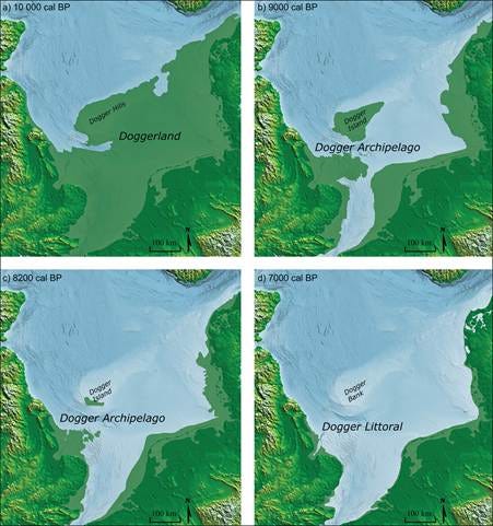
Although the North Sea looks permanent if you look at it on a map, it really seems as if it has always held Britain apart from continental Europe. Yet not long ago in geological terms, much of that water covered a living landscape with rivers, wetlands that fed birds and fish, red deer, wild boar, bear, and people who moved across a land that later generations would never know existed.
This lost landscape is what archaeologists call it Doggerland. A strange name, I know, it sounds like a fantasy kingdom (with dogs?), but the evidence is real. Ancient river systems were traced below the seabed, layers of peat, bones and tools hauled up by fishing boats, pollen and environmental DNA preserved in sediment cores, and seismic maps that reveal contours now hidden under water.
Doggerland however, did not magically vanish in a single day. The sea advanced for thousands of years, as the climate warmed after the last ice age. But around 8,150 years ago, a colossal submarine landslide off Norway sent a tsunami through the North Sea. Did that wave destroy the final communities living there? Or did it strike a landscape already breaking apart, leaving people to adapt and return until the rising sea won anyway?
The answer to this question changes Doggerland from a simple story of a sunken land into something different and more human. That is a homeland that may have been lost slowly, violently, or both.
